Jump to content
IMPORTANT ANNOUNCEMENT ABOUT LOGGING IN ×
  • WELCOME GUEST

    It looks as if you are viewing PalmTalk as an unregistered Guest.

    Please consider registering so as to take better advantage of our vast knowledge base and friendly community.  By registering you will gain access to many features - among them are our powerful Search feature, the ability to Private Message other Users, and be able to post and/or answer questions from all over the world. It is completely free, no “catches,” and you will have complete control over how you wish to use this site.

    PalmTalk is sponsored by the International Palm Society. - an organization dedicated to learning everything about and enjoying palm trees (and their companion plants) while conserving endangered palm species and habitat worldwide. Please take the time to know us all better and register.

    guest Renda04.jpg

A DAY ON THE ROAD


amazondk

Recommended Posts

I have posted quite a few pictures previously of the area between Manaus and Boa Vista, Roraima.  I hope some more will be enjoyed.  While driving north last Friday to Boa Vista with a stop in Rorainopolis, 475 kms north of Manaus, I got inspired while thinking about Gileno's road trip, shots of Fiji by Jim, and Dave's Southern California street drive by shots.  So I took a few pictures of the days trip.  I left Manaus around 9 AM.  I did not start taking pictures until somewhat north of Manaus, but I guess that is ok.  The road, BR 174 which goes to Caracas is a real mess.  It takes about 6 hours to travel the 475 kms to Rorainopolis.  I never get tired of looking at the Mauritias and other palms along the way.  The Mauritia flexuosa, our Buriti, is to me the best symbol of our forest.  I hope some of you enjoy the trip.  It was a good day on the road.

Start of the photo tour.

Roadtrip1.jpg

Some cows on the road.

Roadtrip2.jpg

Buritis and water a scene very common along the road.

Roadtrip3.jpg

The hole has been here for some time.  At least 3 or 4 years.  It used to have an old stove in front of it as a barrier.  Then they decided to put up some signs.  But, nothing as to fixing the hole.

Roadtrip5.jpg

Don Kittelson


LIFE ON THE RIO NEGRO

03° 06' 07'' South 60° 01' 30'' West

Altitude 92 Meters / 308 feet above sea level

1,500 kms / 932 miles to the mouth of the Amazon River


Manaus, Amazonas, Brazil - A Cidade da Floresta

Where the world´s largest Tropical Rainforest embraces the Greatest Rivers in the World. .

82331.gif


Click here to visit Amazonas

amazonas2.jpg

Link to comment
Share on other sites

I always liked this little house framed by palms.

Roadtrip6.jpg

A group of Elaeis oleifera, at least that is how I think you spell it.  The american oil palm relative of the african oil palm.

Roadtrip12.jpg

This hill is very misleading.  It is a major problem for heavily loaded trucks going to Manaus.  I had a trucker get stuck here with a load of wood for 3 days.  Finally I had to charter a another semi tractor in Manaus to pull the trailer up the hill.

Roadtrip13.jpg

This is one of the largest cattle ranches in the Amazonas state side of the trip.  

Roadtrip14.jpg

Don Kittelson


LIFE ON THE RIO NEGRO

03° 06' 07'' South 60° 01' 30'' West

Altitude 92 Meters / 308 feet above sea level

1,500 kms / 932 miles to the mouth of the Amazon River


Manaus, Amazonas, Brazil - A Cidade da Floresta

Where the world´s largest Tropical Rainforest embraces the Greatest Rivers in the World. .

82331.gif


Click here to visit Amazonas

amazonas2.jpg

Link to comment
Share on other sites

Since I left Manaus sort of late and it was around 11 AM I decided to stop for an early lunch.  The roadside restaurants do not have much of a variety on the menu.  But, some have good home cooked food.  This one had some trucks, so I figured it must be ok.  The road ahead did not have too much food.  So, I stopped to try it out.

roadtrip16.jpg

The place had a few truckers having lunch.  The menu was meat and chicken.

Roadtrip17.jpg

I chose the Galinha Caipira, or country chicken.  The chicken was raised on the spot, killed, and put into the pot.  It was quite good.  I also had some fresh coconut water.  The pitcher had 2 coconuts of water in it.  

Roadtrip19.jpg

The restaurant was quite clean and had a simple but very clean rest room.  A very important thing to know where these are a road trip in this area.

Roadtrip20.jpg

Don Kittelson


LIFE ON THE RIO NEGRO

03° 06' 07'' South 60° 01' 30'' West

Altitude 92 Meters / 308 feet above sea level

1,500 kms / 932 miles to the mouth of the Amazon River


Manaus, Amazonas, Brazil - A Cidade da Floresta

Where the world´s largest Tropical Rainforest embraces the Greatest Rivers in the World. .

82331.gif


Click here to visit Amazonas

amazonas2.jpg

Link to comment
Share on other sites

It is now the end of the summer dry season in our area of Amazonas but the year has been pretty wet.  The grass here shows that it has not been very dry.  As you drive north into Roraima the seasons flip and you go into the end of the winter rainy season.

Roadtrip21.jpg

At the 200 km mark the road goes into the Indian Reservation.  Here the road becomes a runway.  But, one full of holes.  I don't think I would want to land a plane here.

Roadtrip22.jpg

The entrance of the Indian Reservation is closed from 6 PM to 6 AM to trucks and passenger cars.  Buses to go through.  Since it is 129 kms of pretty much wilderness I don't think I would want to go at night anyway.  The buses hit jaguars and other animals at night every once in a while.

Roadtrip24.jpg

The Balbina Lake Reservoir ends in the reservation.  It is about 200 kms down to the dam from here.

Roadtrip25.jpg

Don Kittelson


LIFE ON THE RIO NEGRO

03° 06' 07'' South 60° 01' 30'' West

Altitude 92 Meters / 308 feet above sea level

1,500 kms / 932 miles to the mouth of the Amazon River


Manaus, Amazonas, Brazil - A Cidade da Floresta

Where the world´s largest Tropical Rainforest embraces the Greatest Rivers in the World. .

82331.gif


Click here to visit Amazonas

amazonas2.jpg

Link to comment
Share on other sites

This is the map of the reservation.  There are 1,500 indians in an enormous area.

Roadtrip26.jpg

This sign is advising that there is a natural monkey overpass ahead.

Roadtrip27.jpg

Here is the monkey overpass.  I haven't seen any monkies yet, but I suppose they do use it.

Roadtrip28.jpg

This is pretty much the end of Balbina Lake.  Some years ago, 1997, the lake was nearly drained due to a problem with the generators at the dam and the year was unusually dry.  The dry lake bed burned over an immense area and all of the lake the dead trees are burned.  The smoke was so bad that street lights came on in Manaus during the day.  The power problem was also bad.  Every neighborhood had 4 hours a day of no power.

Roadtrip30.jpg

Don Kittelson


LIFE ON THE RIO NEGRO

03° 06' 07'' South 60° 01' 30'' West

Altitude 92 Meters / 308 feet above sea level

1,500 kms / 932 miles to the mouth of the Amazon River


Manaus, Amazonas, Brazil - A Cidade da Floresta

Where the world´s largest Tropical Rainforest embraces the Greatest Rivers in the World. .

82331.gif


Click here to visit Amazonas

amazonas2.jpg

Link to comment
Share on other sites

Entering the state of Roraima.

Roadtrip31.jpg

There are a lot of Angelim Ferro trees along the road.  These are one of our lumber species and are some of the biggest trees in the forest.  You can always spot them by their sprawling crowns.

Roadtrip32.jpg

I stopped to stretch my legs next to this pond.

Roadtrip33.jpg

Roadtrip34.jpg

Don Kittelson


LIFE ON THE RIO NEGRO

03° 06' 07'' South 60° 01' 30'' West

Altitude 92 Meters / 308 feet above sea level

1,500 kms / 932 miles to the mouth of the Amazon River


Manaus, Amazonas, Brazil - A Cidade da Floresta

Where the world´s largest Tropical Rainforest embraces the Greatest Rivers in the World. .

82331.gif


Click here to visit Amazonas

amazonas2.jpg

Link to comment
Share on other sites

The drive is an adventure and the holes in the road have only been getting bigger.  Ths area was filled with a lot of truck loads of earth, but is still a mess.

Roadtrip37-1.jpg

Trucks always common on the drive.  You have to have a lot of patience to navigate this road in a loaded truck.

Roadtrip36.jpg

Roadtrip35.jpg

The palms always keep me company while driving along listening to music.

Roadtrip38.jpg

Don Kittelson


LIFE ON THE RIO NEGRO

03° 06' 07'' South 60° 01' 30'' West

Altitude 92 Meters / 308 feet above sea level

1,500 kms / 932 miles to the mouth of the Amazon River


Manaus, Amazonas, Brazil - A Cidade da Floresta

Where the world´s largest Tropical Rainforest embraces the Greatest Rivers in the World. .

82331.gif


Click here to visit Amazonas

amazonas2.jpg

Link to comment
Share on other sites

The end of the Indian Reservation at the village of Jundiá.

Roadtrip39.jpg

The Urban area of Jundiá.  It is a pretty out of the way place.  Not any many tours.

Roadtrip40.jpg

The only hotel in Jundiá.  I have not tried this one yet.  I don't think that it has a star.

roadtrip42.jpg

Although it is still raining a few grass fires to clear pastures are popping up.

Roadtrip43.jpg

Don Kittelson


LIFE ON THE RIO NEGRO

03° 06' 07'' South 60° 01' 30'' West

Altitude 92 Meters / 308 feet above sea level

1,500 kms / 932 miles to the mouth of the Amazon River


Manaus, Amazonas, Brazil - A Cidade da Floresta

Where the world´s largest Tropical Rainforest embraces the Greatest Rivers in the World. .

82331.gif


Click here to visit Amazonas

amazonas2.jpg

Link to comment
Share on other sites

As you go north the landscape changes in areas to seasonally flooded lands with dwarf forest.  The water is very black as it is in the Negro River.  It does eventually end up in the Negro and flows past Manaus.

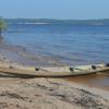
I liked this scened with the canoe sunk by the little cabana.

Roadtrip47.jpg

Roadtrip48.jpg

Roadtrip49.jpg

Roadtrip52.jpg

Don Kittelson


LIFE ON THE RIO NEGRO

03° 06' 07'' South 60° 01' 30'' West

Altitude 92 Meters / 308 feet above sea level

1,500 kms / 932 miles to the mouth of the Amazon River


Manaus, Amazonas, Brazil - A Cidade da Floresta

Where the world´s largest Tropical Rainforest embraces the Greatest Rivers in the World. .

82331.gif


Click here to visit Amazonas

amazonas2.jpg

Link to comment
Share on other sites

There are not many houses along the road and most are pretty much like this.  That is aside from the ranch house here and there.

Roadtrip51.jpg

I could not resist stopping to take a picture of these horses enjoying the afternoon.  I thought of Kitty when I saw them.

Roadtrip50-1.jpg

Another house along the road.

Roadtrip46.jpg

More Buritis.  These had been burned many times I believe.

roadtrip45.jpg

Don Kittelson


LIFE ON THE RIO NEGRO

03° 06' 07'' South 60° 01' 30'' West

Altitude 92 Meters / 308 feet above sea level

1,500 kms / 932 miles to the mouth of the Amazon River


Manaus, Amazonas, Brazil - A Cidade da Floresta

Where the world´s largest Tropical Rainforest embraces the Greatest Rivers in the World. .

82331.gif


Click here to visit Amazonas

amazonas2.jpg

Link to comment
Share on other sites

It is always an intersting point as you pass across the equator.  This line is the middle of the world.

Roadtrip54.jpg

A few kms up the road is the Vila do Equador.  It is a small town which has it's main point a bus stop.

Roadtrip56.jpg

It is sort of a wide spot in the road.

Roadtrip57.jpg

Via do Equador suburban area.

Roadtrip58.jpg

Don Kittelson


LIFE ON THE RIO NEGRO

03° 06' 07'' South 60° 01' 30'' West

Altitude 92 Meters / 308 feet above sea level

1,500 kms / 932 miles to the mouth of the Amazon River


Manaus, Amazonas, Brazil - A Cidade da Floresta

Where the world´s largest Tropical Rainforest embraces the Greatest Rivers in the World. .

82331.gif


Click here to visit Amazonas

amazonas2.jpg

Link to comment
Share on other sites

The Brazil Nut tree is very common in this area.  Since they can not be cut they are left in the pastures.  The tucumã palm is also very common as it does well in this environment.

Roadtrip55.jpg

One of the last milestones of the trip is crossing the Jauaperi River just before my first stop at the town of Nova Colina.

Roadtrip59.jpg

Finally arriving at the urban limits of Nova Colina.  I suppose there are about 3,000 people living there or so.  We have two sawmills working for us here.  So, it is an important destination.  

Roadtrip60.jpg

The last part was the 40 km trip from Nova Colina to Rorainoplis.  The sun was going down, it was about 6:15 PM.  This cloud framed by some tucumâ palms was really striking.  The macaws are always flying back and forth the road which I always enjoy.  The day was a nice one.  Lots of nature and studded with palms.  I am now in Boa Vista and will be heading back south tomorrow.  

Roadtrip61.jpg

Don Kittelson


LIFE ON THE RIO NEGRO

03° 06' 07'' South 60° 01' 30'' West

Altitude 92 Meters / 308 feet above sea level

1,500 kms / 932 miles to the mouth of the Amazon River


Manaus, Amazonas, Brazil - A Cidade da Floresta

Where the world´s largest Tropical Rainforest embraces the Greatest Rivers in the World. .

82331.gif


Click here to visit Amazonas

amazonas2.jpg

Link to comment
Share on other sites

Great pictures! I love those palms on the side of the road, just sitting there, and up here in california, you would kill for a lot of those palms. Nice tour around your area. Is that a busy road?

Meteorologist and PhD student in Climate Science

Link to comment
Share on other sites

beautiful pictures and scenery.  Thanks for sharing.

Kent in Kansas.

Gowing palm trees in the middle of the country - Kansas.

It's hot in the summer (usually) and cold in the winter (always).

Link to comment
Share on other sites

Don,

Never get tired of seeing photos from your various road trips. Truly a unique landscape and for the most part looks completely undeveloped. Is there much traffic to Venezuela on that road, or is it mostly local?

Bo-Göran

Leilani Estates, 25 mls/40 km south of Hilo, Big Island of Hawai'i. Elevation 880 ft/270 m. Average rainfall 140 inches/3550 mm


Link to comment
Share on other sites

I love Brazil. Fantastic fantastic pics.

Its getting my adrenalin pumping just looking at them because its not long to go before my annual trip.

Resident in Bristol UK.

Webshop for hardy palms and hybrid seeds www.hardy-palms.co.uk

Link to comment
Share on other sites

Wow, Don, you did a great job. That's a lot of work to take and post all those photos.  I loved the monkey overpass!  It would seem that if your vehicle breaks down anywhere on that desolate road, you'd be in big trouble.   It is so nice to NOT see thousands of cars in a traffic jam as is so common here.  Are there many gas stations along the way?   Still love the painted equator line!  Thanks for taking us along for the ride! :D

C from NC

:)

Bone dry summers, wet winters, 2-3 days ea. winter in low teens.

Siler City, NC

Link to comment
Share on other sites

As always your "photo trips" are very interesting, showing many different aspects of life and scenery along the way, not to mention all the beautiful palm vistas too.  Most of the area that you traveled here appears to be a rather flat landscape, lacking major hills or mountains.  Is there much trucking of goods across the Venezuelan border on this road?  

Again thanks for sharing and take more pics on your next trip.  We never tire of seeing pics from your trips - even repeat trips.

Hawaii Island (Big Island), leeward coast, 19 degrees N. latitude, south Kona mauka at approx. 380m (1,250 ft.) and about 1.6 km (1-mile) upslope from ocean.


No record of a hurricane passing over this island (yet!).  

Summer maximum rainfall - variable averaging 900-1150mm (35-45") - Perfect drainage on black volcanic rocky soil.  

Nice sunsets!

Link to comment
Share on other sites

Don!

Love the pictures!

All of them!

Hmm.  Glad I inspired you . . . . .

Hope the inspiration keeps coming.  How about some pics of the big cities?  

I'll do thread on a Journey Through East LA . . . .

dave

Let's keep our forum fun and friendly.

Any data in this post is provided 'as is' and in no event shall I be liable for any damages, including, without limitation, damages resulting from accuracy or lack thereof, insult, or lost profits or revenue, claims by third parties or for other similar costs, or any special, incidental, or consequential damages arising out of my opinion or the use of this data. The accuracy or reliability of the data is not guaranteed or warranted in any way and I disclaim liability of any kind whatsoever, including, without limitation, liability for quality, performance, merchantability and fitness for a particular purpose arising out of the use, or inability to use my data. Other terms may apply.

Link to comment
Share on other sites

Outstanding photography with story lines, absolutely brilliant Don. This is wonderful work and I appreciate it enormously and so would the rest of the world.

What great photos these are:

Roadtrip47.jpg

Roadtrip48.jpg

Happy Gardening

Cheers,

Wal

Queensland, Australia.

Link to comment
Share on other sites

Wow...thanks Don...we know how long it took to write and post those photos....thanks for thinking of us....beautiful unspoiled countryside.

Rick Leitner

Fort Lauderdale, Florida

26.07N/80.15W

Zone 10B

Average Annual Low 67 F

Average Annual High 84 F

Average Annual Rainfall 62"


Riverfront exposure, 1 mile from Atlantic Ocean

Part time in the western mountains of North Carolina

Gratefully, the best of both worlds!

Link to comment
Share on other sites

Thanks  everyone I am glad you enjoyed the days ride.  I just got home to Manaus yesterday.   I met my partner in Boa Vista and we drove back to Manaus stopping in Rorainoplis on the way.  I was in pretty much of a rush so I did not get any pictures taken.  As to the traffic it is constant but never busy.  Since the road is so bad most people fly to Manaus or take the bus.  There are now 4 non stop jet flights to Manaus with pretty good fares.  As to the traffic to Venezuela there is more from Boa Vista to Venezuela than from Manaus.  Venezuela buys a lot of it's construction lumber from Roraima as well as some soy beans and other products.  Roraima buys limestone for soil correction and some other things.  But, for the most part Venezuela consumes much more from Brazil.  There is an electric line that runs from Venezuela to Boa Vista as well.  Since the border of Venezuela and Brazil is a duty free area on the Venezuelan side, Santa Helena, a lot of people from Boa Vista drive the 250 km trip to buy electronics and stuff.  It is about 1,200 kms from Boa Vista to the Venezuelan caribbean island resort town of Margarita.  The road gets much better once you cross into Venezuela.  Asphalt is real cheap there so they use a lot of it on the highway.  There are road crews back on the road in both Amazonas and Roraima doing repair.  But, it remains to be seen if any of what they will be doing will stand up for very long.  

Bo, the area has the lowest population density per km2 in Brazil.  That is the Western Amazon region.  For the most part once you get 500 to 1000 meters off the road it is just forest.  As you get into the Rorainoplis area there are side feeder roads called Vincinais, that were made by INCRA the national agrarian reform authority of the federal governent.  On these roads lots are given out of 50 hectares to each family for agriculture.  The property remains federal domain for a long time before any titles are given.  But, the residents have possession.  They can clear 9 hectares of the 50 hectares for farming.  This can be done in three years of 3 hectares per year cleared.  This is a major source of lumber as the only options are sell it or burn it.  The settler has to submit a request with a rough inventory of what trees are on the lot to FEMAT, the Roraima State Environmental Agency, to obtain a license for conversion of forest to farm land.  The lumber company then comes and clears the land for them and removes the logs.  The going rate paid the settler for the logs is 12 USD per m3.  The normally get around 40 m3 of lumber per hectare.  So per year for three years they sell around 120 m3 of logs or 1,440 USD per year.  This may not sound like much, but it is at least half of what they could expect to make in a year, if not equal to, by farming.  In fact what happens a lot is they sell the wood and they abandon the property.  In reality the forest is so large that this makes a small dent into it.  And, a lot of the area ends up reverting to forest as the settlers leave.  

We have one supplier who is the largest rancher in the area.  He has about 60,000 hectares of land.  We are going to see about getting FSC (Forest Stewardhip Council) certification for his ranch.  This means that he has to meet sustainable forestry guidelines by an outside auditing firm connected to Smart Wood.  When talking to him over a BBQ and pool game the other night he had some interesting points.  One is that he does not allow hunting on his land.  I think he has a good point.  The more game he gets the less the jaguars will be interested in his cows.  He has a heard of 8,000.  The other is the carrying capacity of the pasture.  He uses a system they call piquetes.  They fence the pasture in 20 hectare areas.  They put say 200 head of cattle in the pasture for 2 days of grazing.  Then they move them to the next area.  This means that the cow moves little as they are  somwhat confined, and that they do not do too much damage to the grass.  He says that a cow has 5 mouths.  One on their head and each foot.  The cow walking around the pasture destroys as much grass as they eat.  When the cows are moved to the next compartment they apply fertizler and nitrogen to the grass to speed regrowth in the one just grazed.  So when the cows eventually  get back to that compartment the grass has regrown up to maybe 2 feet or more.  Since there is actually moisture all year long, even some duriing the dry season the grass pretty much keeps growing all year.  The maximum area that can be converted to pasture in this case is also 20 percent of usable land with set backs from water courses.  What his model shows is that the argument that cattle ranching is not viable in the Amazon is not really true.  Although the soil is poor if it is managed correctly it can produce sustainable pasture land with a relatively high density of cattle per hectare.  The averge he has is about 2 cows per hectare.  Back in my home state the carrying capacity on range land is more than likely no better than 1 cow per 15 hectares.    On a future trip I am going to spend some time out on his ranch.  The ranch house is located directly on the river shown above the Jauaperi.  He has a real nice ranch house there, boats to go fishing, horses to ride, and a lot of forest to poke around in.  

Al, the landscape from Manaus north is pretty much rolling hills or flat until you get north of Rorainopolis, 475 kms from Manaus.  There mountains start appearing.  I have posted pictures of this area previously.  

Dave, I can't wait to see East LA.  I am taking pictures bit by bit to put together a thread on street scenes of Manaus and city palms.  The latest phone I purchased the Nokia N73 is great for this.  People do not pay attention to you taking pictures with a cell phone as much as with a camera.  The phone was used for all of the pictures above.  Some of them are not as good as with my digital camera.  But, for the most part they come out good. I still have not learned how to tweak the setting on the camera mode, so I think there is still room for improvement.  Since I need to take work pictures as well it comes in real handy.

Here are some pictures that I forgot to upload for the thread.  The wireless connection at the hotel in Boa Vista was not the best so it took a long time on off hours to get these pictures up to photobucket.

This road sign was a few kms south of the indian reservation.  It looks like some truck was a bit high.

As you can see Caracas is still over 2,000 kms away.

Wal,

I am glad you liked those pictures.  It was a real pretty sight to see.

placa.jpg

I really liked the folage on this roadside tree that was in bloom.

Roadtrip8-1.jpg

Roadtrip7-1.jpg

Don Kittelson


LIFE ON THE RIO NEGRO

03° 06' 07'' South 60° 01' 30'' West

Altitude 92 Meters / 308 feet above sea level

1,500 kms / 932 miles to the mouth of the Amazon River


Manaus, Amazonas, Brazil - A Cidade da Floresta

Where the world´s largest Tropical Rainforest embraces the Greatest Rivers in the World. .

82331.gif


Click here to visit Amazonas

amazonas2.jpg

Link to comment
Share on other sites

Anyone - is this a mature Schizolobium parahybum in habitat, maybe?

Doug Gavilanes

Garden Grove, CA.

Zone 10A (10B on really good days...)

Link to comment
Share on other sites

Thanks for the pics Don.

I always enjoy your travels.

The Buriti is my favourite palm as nothing looks at all like it. I have a few growing on our place here.

Looks like the roads there also suffer from the high rainfall and heavy loads like here.

Jim

Located on Vanua Levu near Savusavu (16degrees South) Elevation from sealevel to 30meters with average annual rainfall of 2800mm (110in) with temperature from 18 to 34C (65 to 92F).

Link to comment
Share on other sites

Jim,

From the pictures you posted it looks like your roads there have similarities to ours around here.  If the roads were made well to start with and then maintained there would not be such a problem.  What has happened is also that funds for road improvement have many times gone into peoples pockets not the roads.  And, by making poor repair jobs the contractors assure work for next season.  Much of the road that was repaired before the rainy season started in May in Roraima is now a mess.  The whole road is now suppposed to be redone.  But, I won't hold my breath.  I do intend on getting a pickup truck though.  In addition to the maintanence there is no control on the weight of trucks.   Do they use the fruits of the Buriti in Fiji?  They are highly nutritious and can be made into drink, flour, and one of my favorites is ice cream and frozen fruit bars.

dk

Don Kittelson


LIFE ON THE RIO NEGRO

03° 06' 07'' South 60° 01' 30'' West

Altitude 92 Meters / 308 feet above sea level

1,500 kms / 932 miles to the mouth of the Amazon River


Manaus, Amazonas, Brazil - A Cidade da Floresta

Where the world´s largest Tropical Rainforest embraces the Greatest Rivers in the World. .

82331.gif


Click here to visit Amazonas

amazonas2.jpg

Link to comment
Share on other sites

Hi Don,

That is exactly the same scenario with the roads in Fiji. No descent compaction of base material and drainage for a start and then all the shortcuts so that a few fat cats gain plenty. However in the last couple of years there has been some better attempts made but the over-loaded logging trucks do the damage. There are regulations but they are not so hard to get around.

We are the only place here with the Buriti Palm and one other that I sold. Ours are only six year old and one in the ground is about 8 to 10 foot and not yet showing a trunk but the leaf form is true to kind. They grow so much faster in the ground than ones still in bags. I want to get more seed and see many more of these around Fiji. They are so unique in appearance at any age and from any distance.

Keep on capturing those images and I will look forward to Buriti icecream one day.

Jim

Located on Vanua Levu near Savusavu (16degrees South) Elevation from sealevel to 30meters with average annual rainfall of 2800mm (110in) with temperature from 18 to 34C (65 to 92F).

Link to comment
Share on other sites

Jim,

Seeds are no problem around here.  If I can get the people at the Ministry of Agriculture to give me export clearance I can send a lot of them.  I should know about that this week.  I have been trying to send a box of Euterpe seeds and have been chasing all around Manaus to get this done.  I was out last week, but this week I hope to get this fixed.  Is there any problem in Fiji brining in seeds?

dk

Don Kittelson


LIFE ON THE RIO NEGRO

03° 06' 07'' South 60° 01' 30'' West

Altitude 92 Meters / 308 feet above sea level

1,500 kms / 932 miles to the mouth of the Amazon River


Manaus, Amazonas, Brazil - A Cidade da Floresta

Where the world´s largest Tropical Rainforest embraces the Greatest Rivers in the World. .

82331.gif


Click here to visit Amazonas

amazonas2.jpg

Link to comment
Share on other sites

(gavilan1 @ Nov. 02 2007,18:24)

QUOTE
Anyone - is this a mature Schizolobium parahybum in habitat, maybe?

Doug,

I think that I figured out what tree the picture is.  According to my book it is the Stryphnodendron pulcherrimum or known locally as the timbauba.  It is a secondary forest tree.  It is a nice looking tree I think.

dk

Don Kittelson


LIFE ON THE RIO NEGRO

03° 06' 07'' South 60° 01' 30'' West

Altitude 92 Meters / 308 feet above sea level

1,500 kms / 932 miles to the mouth of the Amazon River


Manaus, Amazonas, Brazil - A Cidade da Floresta

Where the world´s largest Tropical Rainforest embraces the Greatest Rivers in the World. .

82331.gif


Click here to visit Amazonas

amazonas2.jpg

Link to comment
Share on other sites

Don,

Thanks a lot for all the additional information. And another 2000 km to Caracas - wow, that's a good distance! What does that translate into? 2 or 3 days drive?

Bo-Göran

Leilani Estates, 25 mls/40 km south of Hilo, Big Island of Hawai'i. Elevation 880 ft/270 m. Average rainfall 140 inches/3550 mm


Link to comment
Share on other sites

Thanks Don i will send you a PM.

Jim

Located on Vanua Levu near Savusavu (16degrees South) Elevation from sealevel to 30meters with average annual rainfall of 2800mm (110in) with temperature from 18 to 34C (65 to 92F).

Link to comment
Share on other sites

I always liked this little house framed by palms.

Roadtrip6.jpg

Euterpe precatoria....soooo nice.........(faints while swooning and smile on face) :P

Matt Bradford

"Manambe Lavaka"

Spring Valley, CA (8.5 miles inland from San Diego Bay)

10B on the hill (635 ft. elevation)

9B in the canyon (520 ft. elevation)

Link to comment
Share on other sites

Bo,

If the Brazilian side of the road were in good shape I think you could make it ok to Caracas with 2 long days on the road from Manaus.   That would be 2,200 kms.  But, under current condtions it would more than likely mean three days.  It takes at about 10 hours to drive the 750 kms to Boa Vista.  From what I am told once you get into Venezuela the roads are much better and quicker to travel.  And, with gasoline at .12 USD cents per liter the trip is pretty cheap.  The gasoline in Venezuela is basically for free the price comes from gas station overhead.

Matty,

I think I owe you some Euterpe seed.  Hopefully I can get the red tape situation fixed this week and send some out.  They got things real confusing at the post office when I tried a few weeks ago.  I will let you know.

dk

Don Kittelson


LIFE ON THE RIO NEGRO

03° 06' 07'' South 60° 01' 30'' West

Altitude 92 Meters / 308 feet above sea level

1,500 kms / 932 miles to the mouth of the Amazon River


Manaus, Amazonas, Brazil - A Cidade da Floresta

Where the world´s largest Tropical Rainforest embraces the Greatest Rivers in the World. .

82331.gif


Click here to visit Amazonas

amazonas2.jpg

Link to comment
Share on other sites

No problem Don.  I just love your pictures of your life in Brazil.  Maybe instead of sending me Euterpe prec. seeds you could just sign me up for the weekly Euterpe p. photo subscription. :P

Matt Bradford

"Manambe Lavaka"

Spring Valley, CA (8.5 miles inland from San Diego Bay)

10B on the hill (635 ft. elevation)

9B in the canyon (520 ft. elevation)

Link to comment
Share on other sites

Don, thanks again for another wonderful trip! as I've mentioned many times before, I always look forward to your posts. It's almost like I've left this dry desert of a place!!  :P

Dave Hughson

Carlsbad, Ca

1 mile from ocean

Zone 10b

Palm freaks are good peeps!!!!!

Link to comment
Share on other sites

Don,

Is Angelim Ferro, Hymenolobium heterocarpum?  I picture it looking similar to the Enterolobium grown here but with much larger leaflets.  Is that a good description?

Thank you for your photo journal, it really gets me lusting for a trip soon.  I'm trying to encourage my wife that this is a trip we really need to do.  She's sold on Machu Picchu...I just need to expand it a little.  I also need to get the kids out of the house, so it'll be a little while.

Central Florida, 28.42N 81.18W, Elev. 14m

Zone 9b

Summers 33/22C, Winters 22/10C Record Low -7C

Rain 6cm - 17cm/month with wet summers 122cm annually

Link to comment
Share on other sites

Ron,

The angelim ferro or also known as angelim vermelho is Dinizia excelsa.  The trees are one of the largest forest trees in our area.  I would guess that some of the tallest branches are up to 180 feet high.  It is an easy tree to identify in the forest due to it's size, exfoliating bark, and mound of bark that piles up around it's base.  The wood is extremely resistant, but has a sort of unpleasant dirty foot smell to it until it drys.  I am sure you and your wife will enjoy Amazonia when you make it here.

Dave,

It would be nice if some of our moisture could be sent your way, but I don't think it would make it.

dk

Don Kittelson


LIFE ON THE RIO NEGRO

03° 06' 07'' South 60° 01' 30'' West

Altitude 92 Meters / 308 feet above sea level

1,500 kms / 932 miles to the mouth of the Amazon River


Manaus, Amazonas, Brazil - A Cidade da Floresta

Where the world´s largest Tropical Rainforest embraces the Greatest Rivers in the World. .

82331.gif


Click here to visit Amazonas

amazonas2.jpg

Link to comment
Share on other sites

Don,

Thanks for posting the picture in #10 of the horses.  I can see  mine in the water there!

I love your photo tours.  Keep them coming.  It certainly makes Brazil and Amazonia one of my must-see destinations!

The stillness of the water was beautiful.  And the houses along with the palms is wonderful.

And put me on the list for some Buriti seeds!

Keep the pictures coming.  I know living in a 3rd world country can be a challenge since I've done it but it certainly is worth it!  No traffic jams, beautiful scenery and usually friendly people who know how to enjoy life!  If I was the kind of woman who swooned I would be swooning!  But somehow I missed that part of the Southern Belle education!

Palmmermaid

Kitty Philips

West Palm Beach, FL

Link to comment
Share on other sites

Great tour as always Don!

Steve Johnson

Northeast of Atlanta, GA  

Zone 7b

Perfect weather for humans, borderline for palms

Link to comment
Share on other sites

Create an account or sign in to comment

You need to be a member in order to leave a comment

Create an account

Sign up for a new account in our community. It's easy!

Register a new account

Sign in

Already have an account? Sign in here.

Sign In Now


  • Recently Browsing

    • No registered users viewing this page.
×
×
  • Create New...